Detour information for transit appearing in Google Maps
It seems that Google Maps is testing something new: temporary detour information.
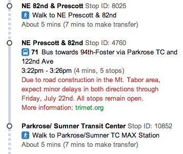
See these results for TriMet:
I’m assuming the information is collected through TriMet’s Web Services API. There are several calls for requesting current detour information.
Does anyone know if this is being tested for other agencies?
There’s a specific API for Google Transit detours: http://developer.trimet.org/ws/V1/FeedSpecAlerts/appid/270FE4740FD758B33BE454622?text=true
It is also being used in San Diego…the spec should be out soon. It was part of the real-time effort.