Rural areas and Google Transit: some findings and opportunities for improvement (Part 2, Intercity service)
This post continues a series of posts on Google Transit and issues that arise for agencies and passengers in rural service areas. The first post explains the goals and origins of this discussion. This post addresses that affect longer-distance inter-city transportation services in Google Maps in particular. Modoc Sage Stage, Trinity Transit, Metrolink and select Amtrak services are a few examples of intercity services that are live in Google Transit.
ISSUE: Queries for travel times more than 48 hours in advance of scheduled service return no results
Some inter-city routes within the project study area operate once or twice each week. Currently, for these services to be returned in the trip planner, the end-user must query for a departure time and date near to the scheduled time of service. If the query is for a desired travel time 48 hours or more in advance of the scheduled service, no results will be returned; to someone who doesn’t already know there is service on that corridor, it looks like there is no service available.
We suggested the Google Transit trip planner should search for and return services that are up to 7 days in the future of the desired travel time.
ISSUE: Maximum walking distance threshold prevents display of available transit service
When the origin or destination entered into the trip planner is farther than four miles from the nearest transit stop, no trip options are returned. We contacted Google Transit Partner Support about the possibility of modifying walking distance thresholds in rural areas.
The recommendation developed with stakeholder input is for the travel to transit stop distance to be increased to 25 miles (that’s a pretty long distance; don’t know if it’s technically feasible). This travel distance to transit can be expected in areas where transit passengers travel over 100 miles to a regional airport in service areas with density of less than 5 persons per square mile, for example. In order to avoid trip planner results where travel-to-transit distance is greater than travel-by-transit distance, the travel-to-transit threshold should be increased for long-distance transit routes.
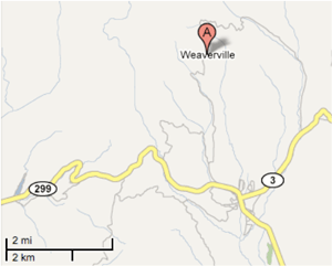
This issue presents a particular problem in instances where end users query for transit destinations and origins by the name of a city. In Google Maps, the discrete points that indicate the location of rural cities may be a significant distance from actual town centers and transit stop locations (see example below).

In rural areas, friends, family, and neighbors sometimes drive transit passengers to bus stops if walking distances are significant. For some commuter rail services, Google has incorporated drive-to-transit directions. This feature may also be useful in rural areas.