CalACT conference attendees can travel Earth-friendly, easily, with Google Transit
 I’m planning to attend the March conference of the California Association for Coordinated Transportation in San Diego. When I was making my travel plans, I used Google Transit to figure out how to travel between the airport and conference location by public transportation, and to see which downtown hotel I could stay at and still conveniently access the conference and airport.
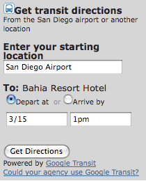
As I was doing this, I noticed that CalACT’s otherwise fine website and conference information page seemed to be missing something: a mention of public transit availability at Lindberg Field, San Diego’s airport. So, I created a transit trip planner form and sent it to the conference organizers to be included as part of the website. The form gives convenient transit directions from any point in San Diego (the airport is the default) to the conference hotel. The date/time values are set to midday the day before the conference, but they can be changed according to when someone’s flight arrives.
The result is shown to the right. You can see the implemented version of this trip planner form on the CalACT conference website.
I hope this helps attendees save a few bucks on travel to the hotel, reduce their carbon footprint, and add a little bit to San Diego MTS‘s farebox revenue. And, who knows… maybe a few transit agency managers and staff will be inspired to implement Google Transit for their agency, and/or leverage Google Transit with strategies like transit trip planner forms in their local online events calendar or features to help webmasters link to transit with badges and simple transit directions forms.
This is powerful transit markeing — not only does an event-specific trip planner form suggest transit at the time when someone is thinking about making a trip, but provides all the tools and information to plan that trip in about 10 seconds.
Nice, I like the text ad 😉
I did something similar but have a button for transit and a button for driving. I also did some ugly javascript to pre-fill the time and date for the correct day-of-week at http://www.underwater-society.org/uwhockey/sanfran/WhereAndWhen.html
A little app that generates these or returns them in an iframe would be nice.