Google Transit: More excessively lengthy intercity itineraries
Google Transit continues to slowly but consistently improve in response to requests from partner transit agencies and end users. For example, the ability to select a preferred mode and type of itinerary (fewer transfers, less walking, etc.). See this earlier blog post on this feature.
Still, there are issues that remain. For intercity transit trips, Google Maps frequently returns long itineraries that could be significantly shortened by walking or driving only a few additional miles.
I’ve posted on this issue before, here. This blog post shows an additional example as described by Matthew Barnes, the Intercity Program Coordinator at the Oregon Department of Transportation’s Public Transportation division.
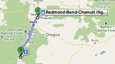
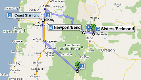
Scenario: A potential transit passenger in Redmond, Oregon is using Google Transit to look for transit options to get to Chemult, Oregon. Not knowing anything about the location of available transit services and stops the potential passenger enters Redmond, OR as the trip origin and Chemult, OR as the trip destination.
Google Transit returns a 12+ hour travel option with three different transit agencies and considerable out of direction travel. From this result, clearly there is no “reasonable” transit available between Redmond and Chemult. The potential transit passenger resigns herself to driving alone.
But wait, by shifting the origin by just 2 miles suddenly there is a transit option with no transfers that takes only two hours. It looks like Google Transit is adding nine and a half hours to this trip in order to save passengers from a two mile trip to transit.
Click an image or link below to see the full itinerary in Google Maps.
Redmond Airport to Chemult, Oregon (origin is ~2 miles from previous example):


I’m not quite sure what’s gong on… playing with the first option, I get the “access to transit” time down to 26 mins with the long route, then if I tweak it slightly, I can get the second route with an access time of 31 mins.
Tom- I’m not sure where you’re deriving the “access to transit” time. Is the “second route” from the Redmond airport?
By “access to transit” time, I mean the time spent on the initial walk/drive before boarding the first transit leg. And yes, by second route, I meant the second (shorter, more direct) route you showed in your post.
If you zoom and move the origin marker around, you get the suggested route to flip between the two. If the origin is on Hwy 97 just north of Hwy 126, it will suggest the long route. If the origin is just *south* of Hwy 126, it will suggest the short route.
It seems that Google has mostly fixed it; the first link now returns a 3 1/2 hour route with one bus transfer. It’s not ideal, but it’s much more direct.
That’s great to see. Thanks for posting the comment.